


Gordano Civic Society

Copyright © 2026 Gordano Civic Society

Founded 1956


Other publications
|
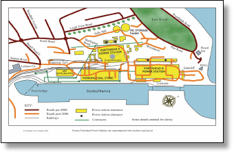
Power Station map This map shows the site of the former Power Stations with the modern road layout superimposed. Size A3 (42 x 29.7 cm). Suitable for framing. This item can be bought at Society meetings. Price: £2 |
|
|
1840 Tithe Maps A complete set of Tithe Maps from 1840 which cover different parts of Portishead, North Weston and Weston-in-Gordano. They give details of ownership and occupation and a description of the land. They are on cream A3 paper and cost £1.50 each. These items can be bought at Society meetings. Maps available: 1. Nore Road/Down Road/Coast line |
|
|
Gordano Round Fully illustrated walks around the Gordano Valley. A colour booklet published by North Somerset Council written by Jim Dyer. Updated in 2011. Available from The Gordano Footpath Group, 3 Harmony Drive, Portishead, Bristol, BS20 8DH. Price is only £5 plus £1 postage. Cheques to be made payable to The Gordano Footpath Group. |

 Main Publications page >>
Pancake Money book
A history of the Chappell Charity
This book by John Haysom is now sold out. One copy is held in our Library which members can borrow. More …
| Mhome |
| Interpretation |
| Weatherly |
| PS gates |
| Posset Pieces |
| Posset Pieces2 |
| Posset Pieces3 |
| Other publications - Gordano Civic Society |
| Portishead history |
| Power Stations |
| Phosphorus |
| Petroleum |
| B details |